by Sue Cag
Last updated: October 2023, all groves personally visited and impacts verified.
Related: Windy Fire Firsthand Report
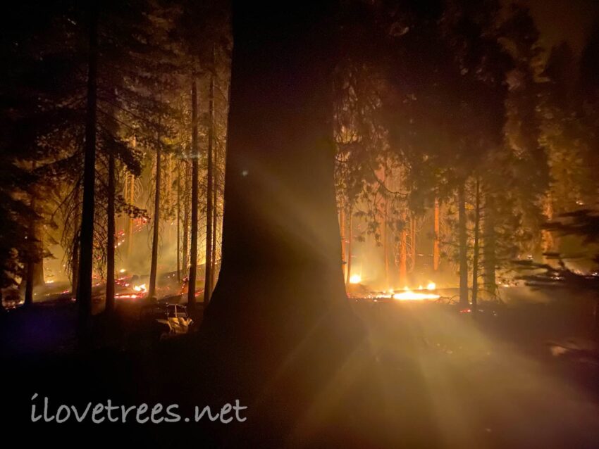
Numerous giant sequoias perished in the 2021 Windy and KNP Complex fires. Combined with the Castle Fire last year, the loss feels immense. The sequoias are harbingers of our planet’s destruction – it’s too hot and too dry, yet we refuse to address climate change. Instead, we continue to destroy our forests through logging, burning, and tree plantations. We won’t even allow the millions of natural post-fire sequoia seedlings to replace their parents, as they are designed to do.
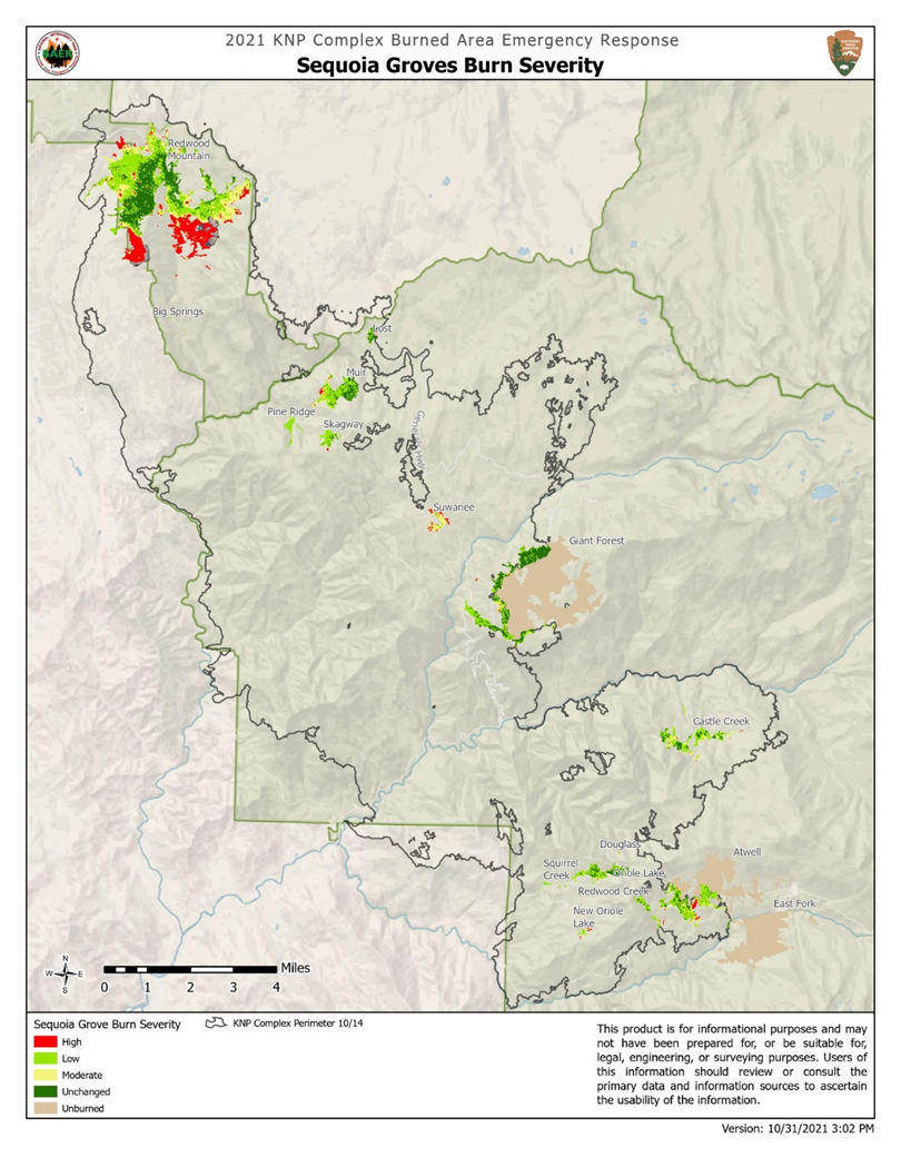
The National Park Service (NPS) has announced that approximately 3,000 large (4+ feet diameter) giant sequoias perished in the KNP Complex and Windy fires combined. The agency’s report shows that the most severely burned NPS groves were Redwood Mountain Grove and Suwanee Grove.
Redwood Mountain had by far the largest amount of area impacted. Several acres burned severely, killing many sequoias. Redwood Mountain burned severely despite the numerous prescribed burns conducted in the grove over the years. The prior unnatural burning actually contributed to the losses. For example, huge thickets of even-aged young trees (caused by prescribed burning) torched adjacent monarchs to death. Further, the giant sequoias that were damaged and compromised by prior prescribed burning are now dead. Most of the giants in the Sugar Bowl area, which was surrounded by extensively logged and burned forest, are dead. The grove is large though, and still contains plenty of surviving sequoias.
A significant portion of Suwanee Grove burned intensely as well (Suwanee was also subjected to prescribed burning). Atwell was impacted on its west side (in areas of past logging), but the remainder of the grove is fine. Castle Creek Grove (an untouched Wilderness grove) burned thoroughly under a pyrocumulus cloud, yet somehow only lost one big sequoia and a few smaller ones. Oriole Grove, Pine Ridge Grove, and Skagway Grove are also fine despite being incredibly dense with trees and snags prior to the fire, due to the lack of human management. Muir Grove was purposely lit prior to the fire and sustained considerable damage. By and large, sequoia groves that weren’t logged, burned, or otherwise “managed” fared better in all of the recent fires. See a complete list of KNP and Windy fire grove conditions below.
 Source: NPS
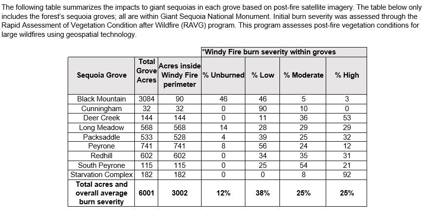
The Forest Service released the following Windy Fire burn severity chart based on satellite imagery. If this information is accurate and 25% of sequoia grove area burned severely, we are looking at a mirroring of last year’s Castle Fire (which severely burned 29% of sequoia grove area). Sequoia death in severely burned areas will be close to 100%. Sequoia loss in moderately burned areas will be around 34% (using data from the NPS Castle Fire study).
Below is the Windy Fire severity map included in the NPS study. It indicates mixed impacts, including severely burned portions in nearly all groves. All of these grove areas have been logged to one degree or another. Starvation Creek fared the worst by percentage, with most of its sequoias killed by the fire. Deer Creek, the small southernmost grove, also lost most of its large sequoias. Packsaddle suffered from “edge effect” due to the close proximity of intensely logged forest and lost some of its sequoias as a result. Long Meadow lost a large number of sequoias in its heavily logged upper portions. Red Hill lost many of its sequoias, especially to the east and southwest. Peyrone and South Peyrone suffered some loss. Cunningham didn’t suffer any losses. See below for a more complete summary of the fire’s impacts.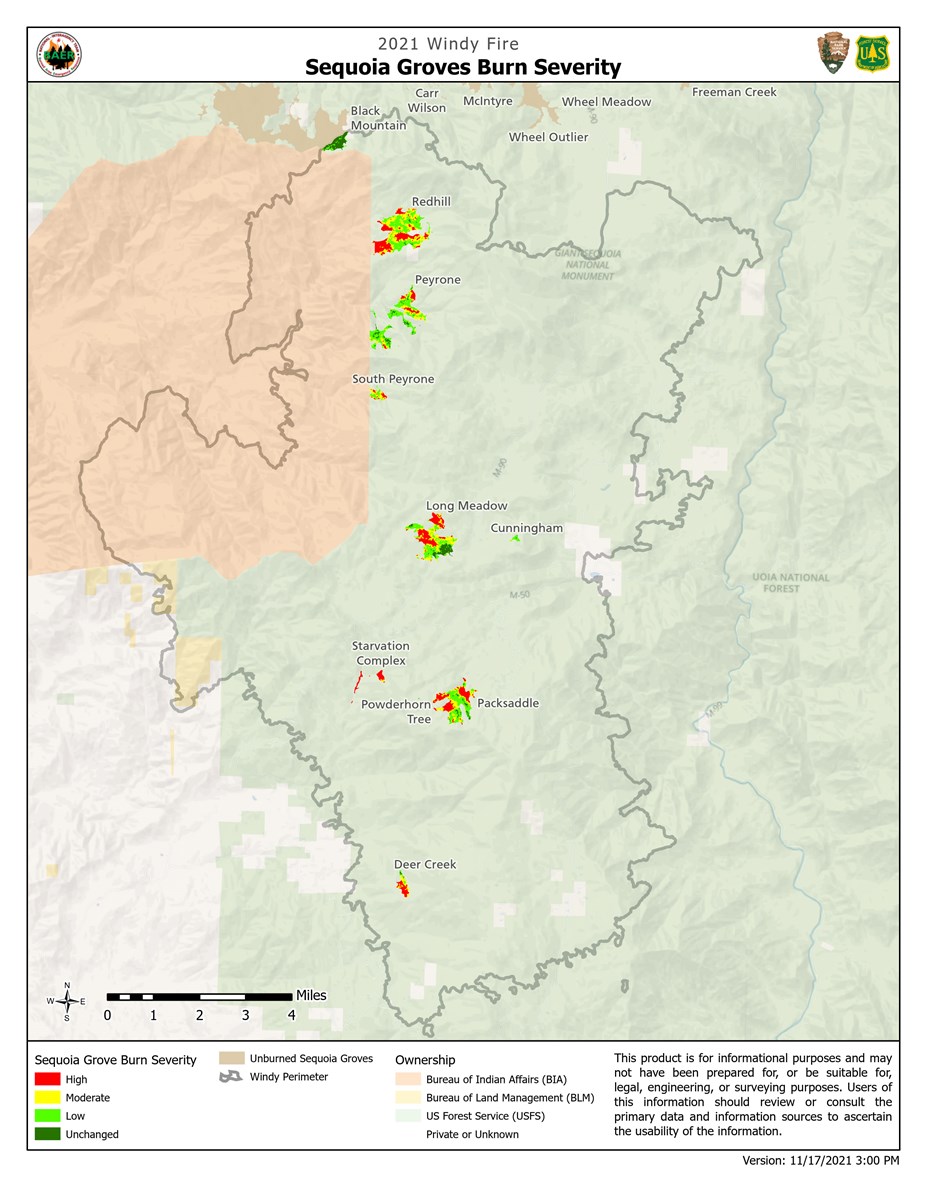
Source: NPS
Groves impacted by the Windy and KNP Complex fires, in alphabetical order:
Atwell-East Fork Grove
The KNP Complex Fire burned the western portion of the Atwell section, from the Redwood Creek area toward the Arm Tree area. Most of the burn was limited to a surface burn, but some areas burned intensely and there are sequoia losses. The NPS report states that: “Where Atwell burned severely, the forest was mostly second growth” (due to pre-park logging). A friend reports that the Arm Tree didn’t burn and none of the named trees in the western section were damaged except for Diamond – the giant survives, but was badly burned through its namesake, digging a cavern deep into the middle of the vertical trunk. One of Touchdown Jesus’ goalposts was turned brown as well.
Black Mountain Grove
The Windy Fire only clipped the very eastern edge of Black Mountain and was limited to a surface burn.
Castle Creek Grove
Castle Creek Grove burned intensely and thoroughly under a pyrocumulus cloud, yet somehow only one big sequoia died (along with smaller ones). Conifers and shrubs surrounding the grove (and within the grove to a lesser extent) burned severely. Most of the wonderful sugar pines inside the grove boundary also survived. There are thousands of glorious sequoia seedlings in Castle Creek as of October 2022 – hopefully (unlike in so many other areas) they will be left alone to flourish.
Cunningham Grove
I’ve personally verified that there were no sequoia losses in Cunningham Grove, despite it burning in its entirety. Unfortunately, “researchers” have been disrespectfullly nailing metal tags into ancient giant sequoia trunks and carelessly trampling sequoia seedlings to death while constructing their research plots.
Deer Creek Grove
Deer Creek Grove burned severely, but retains survivors. The abundant post-fire natural sequoia seedlings are outstanding. Read a firsthand account of the sequoia losses in Deer Creek here: Windy Fire Firsthand Report: Starvation Creek, Deer Creek, Packsaddle, Long Meadow.
Giant Forest
Sequoia losses are limited to the southwest portion of Giant Forest. I counted six dead sequoias and four badly damaged sequoias during a brief drive through (I did not look closely). The fire was limited to the edges of the grove. It was not permitted to rage through the grove as it was in others. The tourist area appears unchanged. The named sequoias were protected. The famous General Sherman tree was not impacted. The KNP Complex Fire was fought along the highway that cuts through the Giant Forest. It is interesting to note the necessity of such an enormous amount of effort to prevent the fire from torching the Giant Forest, despite this area being so heavily prescribed burned. In June 2022, a large portion of the Giant Forest was burned purposely yet again, killing many more giants than any prior wildfire in the grove. A mere year later, several giants are dead on the ground, having been scorched through by prescribed fire. Many more sequoias have had their bark seared off, effectively girdled, and are dying slowly. In five or six years we will see several more “standing dead” sequoias from this overzealous burning (losses that the park will erroneously blame on beetles). All of these dead sequoias are unnamed trees, so the public has yet to react. After a single named sequoia (one of a pair called “Orphans”) was killed by prescribed burning in North Calaveras Grove, there was a public outcry and mourners held memorial services below the tree. Countless intentional deaths like this have occurred in Giant Forest and there hasn’t been a hint of memorial service for any of them.
Long Meadow Grove
Long Meadow experienced mixed impacts. Some areas burned severely and some more moderately. The heavily logged and clearcut areas in the upper portion of the grove burned intensely. Trail of 100 Giants was not impacted by the fire (except by Forest Service activities). Read a firsthand account of the sequoia losses in Long Meadow here: Windy Fire Firsthand Report: Starvation Creek, Deer Creek, Packsaddle, Long Meadow.
Lost Grove
Lost Grove experienced low intensity fire or was control burned during the KNP.
Muir Grove
NPS crews intentionally burned Muir Grove prior to the fire. They killed several sequoias and damaged countless others, some very badly. They killed three of the sequoias you walk under as you enter the grove from the trail, in the “Cathedral” group. The sequoia trunks were burned through and lie lifeless on the ground now. Crews also damaged the thick stocky tree at the “beginning” of the grove, but it only lost its top. More dead sequoias are located out of sight of the casual visitor. It’s a shame that Muir was damaged this way. We’re not sure the fire would even have reached the grove. Sadly, the NPS claims they “saved” Muir Grove. By killing sequoias? Meanwhile, two untouched, completely unmanaged groves located very close by – Pine Ridge Grove and Skagway Grove – fared fine in the fire. Who saved them?
New Oriole Grove
Most of the sequoias in New Oriole Grove survived the fire. A few died or their canopies turned brown recently, perhaps seven of them. There are thousands of incredibly robust sequoia seedlings all across the slope in the most intensely burned section of the grove to the east / southeast.
North Cold Spring Grove
There is no info about how North Cold Spring fared in the Windy Fire since it’s located on the Tule River Indian Reservation.
Oriole Grove
Oriole Grove fared very well in the fire. The grove fared well despite being unlogged, untreated by prescribed fire, and extremely fuel-dense. This lack of human interference allows fire-adapted forests to manage themselves appropriately.
Packsaddle Grove
Packsaddle Grove experienced mixed impacts in the Windy Fire and generally fared well. We lost the Packsaddle Giant and Candelabra, but Ghost lives on. Read a firsthand account of the sequoia losses in Packsaddle here: Windy Fire Firsthand Report: Starvation Creek, Deer Creek, Packsaddle, Long Meadow.
Parker Peak Grove
There is no info about how Parker Peak fared in the Windy Fire since it’s located on the Tule River Indian Reservation.
Peyrone Grove
The Windy Fire started on the Tule River Indian Reservation to the west of Peyrone Grove. It was small and slow moving when it started. It gradually creeped east toward Peyrone, then tore off to the south and east, driven by wind away from the grove. There are several losses in Peyrone, but most of the grove did not burn severely.
Pine Ridge Grove
Pine Ridge did fine in the KNP Complex Fire likely due to it being a wild, untouched, unmanaged grove. The grove burned in its entirety, but lost only two sequoias. Pine Ridge was and still is an incredibly dense forest, wonderfully thick with conifers of all types, including sugar pines. With so much fuel, it should be telling that this grove did not burn intensely.
Red Hill Grove
A significant portion of Red Hill Grove burned severely in the Windy Fire. There are many losses in the east section and the southwest section, in heavily logged areas of the grove.
Redwood Mountain Grove
A significant portion of Redwood Mountain Grove burned severely in the KNP Complex Fire. An enormous pyrocumulus cloud formed over the grove when the fire swept through. Most of the sequoias in the Sugar Bowl area perished. Many monarchs in the southern section of the canyon died. The Hart Tree was damaged and lost its top, but is otherwise ok. The Roosevelt Tree was hollowed out. The Big Springs outliers and the other outliers near them are alive in pockets of green. Scores of sequoias survive in the grove as can be seen from the highway viewpoint. Millions of seedlings are thriving throughout the harshly burned areas, ushering in a new generation of giants, in the natural process sequoias do best.
Skagway Grove
Despite burning in its entirety, Skagway Grove did not suffer any losses due to the KNP Complex Fire. Skagway is another fantastic sequoia grove that lacked human “management” and tended itself.
South Peyrone Grove
Some of the South Peyrone sequoias died in the Windy Fire, but many more live on. The biggest tree in the grove (to the southwest) didn’t make it, but overall, the small grove didn’t fare too badly. The Windy Fire burned down the Mule Peak lookout tower located above the grove (and severely burned the surrounding heavily logged landscape). Crews had wrapped the tower, but it burned down anyway (really wish they wrapped my house rather than old buildings like this).
Starvation Creek Grove
Starvation Creek Grove burned severely in the Windy Fire, killing most of the sequoias, but there are also survivors. Read a firsthand account of the sequoia losses in Starvation Creek here: Windy Fire Firsthand Report: Starvation Creek, Deer Creek, Packsaddle, Long Meadow.
Suwanee Grove
I visited the Suwanee post-fire and found many sequoia skeletons, especially on the western edges of the grove. I also found many surviving giants, especially on the eastern and southeastern sides of the grove. If left alone, the grove will recover as fire-adapted sequoia forests have done for millennia, but unfortunately, park personnel been in there trampling seedlings and making plans to ruin the grove with unnecessary artificial plantings.
Further notes: Suwanee had been prescribed burned. Thickets of small trees that sprouted after prescribed burning surrounded most of the sequoia bases prior to the KNP fire. The grove was also heavily used for grazing (and was likely burned in the past for grazing). The grove lacked large conifers. Two prior severe fires also decimated the forest to the east and to the west of the grove. It’s also unclear if Suwanee burned as a part of natural fire or if fire crews lit the forest intentionally and/or possibly allowed their Giant Forest and Generals Highway back-burns to torch the grove.
![]() About the Author:
About the Author:
Sue Cag is a musician, artist, writer, photographer, and nature preservationist.
All photos and video by Sue Cag. All Rights Reserved. Photos and video may not be used without permission.
